Forged Alliance Forever Forged Alliance Forever Forums 2019-05-04T15:11:07+02:00 /feed.php?f=53&t=17513 2019-05-04T15:11:07+02:00 2019-05-04T15:11:07+02:00 /viewtopic.php?t=17513&p=174336#p174336 <![CDATA[Re: Lachflash's map editing tools]]> I'll have a good look at it. I still have some Ideas I might realize at some point and now I can make sure to keep them compatible to ozonex's editor.

I don't understand whats great about my averaging. I just take the height values of opposing points and average them. There still remains is a seam that has to be cleaned up.

Statistics: Posted by Lachflash — 04 May 2019, 15:11


]]>
2019-05-04T14:45:12+02:00 2019-05-04T14:45:12+02:00 /viewtopic.php?t=17513&p=174333#p174333 <![CDATA[Re: Lachflash's map editing tools]]>
Not many people are using that editor anymore as ozonex created a brand new one that uses the unity engine:

FaF OzoneX Editor

Your tool looks like it does nice work with images and the averaging algorithm is great! Keep it up as the more tools we have, the better!

Statistics: Posted by Morax — 04 May 2019, 14:45


]]>
2019-05-04T14:28:46+02:00 2019-05-04T14:28:46+02:00 /viewtopic.php?t=17513&p=174332#p174332 <![CDATA[Re: Lachflash's map editing tools]]> As far as I am aware the current procedure to make a map point symmetric is described here under "Editing the heightmap in photoshop": https://wiki.faforever.com/index.php?title=Map_Editor
This tool lets you just paint over the parts of the map you want to keep and marks the areas that will be overridden in red.

Statistics: Posted by Lachflash — 04 May 2019, 14:28


]]>
2019-05-04T14:10:31+02:00 2019-05-04T14:10:31+02:00 /viewtopic.php?t=17513&p=174330#p174330 <![CDATA[Re: Lachflash's map editing tools]]>
This is a nice tool by the way! I'm curious to see how it progresses.

Statistics: Posted by Morax — 04 May 2019, 14:10


]]>
2019-05-04T13:48:19+02:00 2019-05-04T13:48:19+02:00 /viewtopic.php?t=17513&p=174329#p174329 <![CDATA[Re: Lachflash's map editing tools]]> Statistics: Posted by Uveso — 04 May 2019, 13:48


]]>
2019-05-04T13:34:45+02:00 2019-05-04T13:34:45+02:00 /viewtopic.php?t=17513&p=174327#p174327 <![CDATA[Re: Lachflash's map editing tools]]> Image
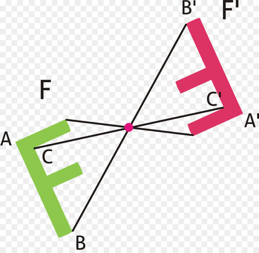
There is no plane of symmetry, just a point.

Statistics: Posted by Lachflash — 04 May 2019, 13:34


]]>
2019-05-04T13:17:46+02:00 2019-05-04T13:17:46+02:00 /viewtopic.php?t=17513&p=174326#p174326 <![CDATA[Re: Lachflash's map editing tools]]> Statistics: Posted by nine2 — 04 May 2019, 13:17


]]>
2019-05-04T12:45:00+02:00 2019-05-04T12:45:00+02:00 /viewtopic.php?t=17513&p=174323#p174323 <![CDATA[Re: Lachflash's map editing tools]]>
point symmetry is hard to explain without images. However many SupCom maps use it. Setons Clutch would be a prime example.

Statistics: Posted by Lachflash — 04 May 2019, 12:45


]]>
2019-05-04T12:34:28+02:00 2019-05-04T12:34:28+02:00 /viewtopic.php?t=17513&p=174321#p174321 <![CDATA[Re: Lachflash's map editing tools]]>
Welcome to FAForever!

What do you mean with "point-symmetric" ?
Does it mirror a map in a specific direction ?

Statistics: Posted by Uveso — 04 May 2019, 12:34


]]>
2019-05-04T13:36:11+02:00 2019-05-04T12:18:53+02:00 /viewtopic.php?t=17513&p=174319#p174319 <![CDATA[Lachflash's map editing tools]]> it takes the .raw files the editor outputs and makes them point-symmetric.
The improvement over using image editing software is that you can use a paintbrush tool to select the areas you want to keep.

Here is an example of using it on a heightmap of the grand canyon:
Image

And here is the result inside the map editor:
Image

As of now this only works with heightmaps, stratums are not supported. Also it only works on square heightmaps but as I understand all our heightmaps are square anyways.

Here is a download link. It also comes with the full source code.
http://www.mediafire.com/file/5b4m1ogt8 ... comRAW.zip

Please let me know if you find any problems with it.

Statistics: Posted by Lachflash — 04 May 2019, 12:18


]]>